by Brian Lazar
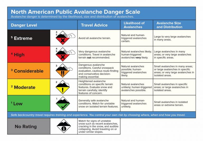
The most basic tool for communicating the avalanche hazard is the avalanche danger rating. We have five ratings to choose from for each elevation band. The danger rating considers the likelihood of avalanches occurring and the potential size of the avalanche. This scale tries to take every possible avalanche situation and put it into one of five categories, but Mother Nature doesn’t always cooperate and conditions often don’t fit neatly into the prescribed boxes. When in doubt the forecasters use the travel advice to pick the danger rating for the day. This usually works well, but there are times when choosing a specific rating gets tricky. Now is one of those times.

Forecasters start using adjectives to qualify the danger rating when things get tricky. For example, when we have a low probability-high consequence Deep Persistent Slab avalanche threat, the term “scary Moderate” starts getting tossed around. It is not “scary moderate” right now, but the sensitivity of the weak layers and the number of remotely triggered avalanches is making the forecasters nervous. Internally we’ve been calling it “spooky Moderate”; there’s a high probability of triggering small to large (D1 to D2) avalanches, but only on specific slopes. On these specific slopes, the snowpack is very sensitive as we have seen lately in our growing list of human-triggered avalanches, but natural avalanches and avalanches larger than D2 are unlikely.

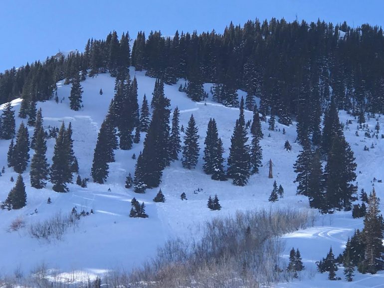
Here is a picture of a large skier-triggered avalanche in the Aspen zone on Jan 16th. Notice the wide propagation of this slide that broke on a persistent weak layer. Persistent Slab avalanches often break wider than Storm or Wind Slab avalanche, and in ways that can be surprising.
This situation doesn’t fit perfectly into either Moderate or Considerable. Looking at the whole picture, Moderate (Level 2) is the best fit for current conditions, but it is by no means safe. Each danger levels covers a spectrum, and we are much closer to Considerable (Level 3) than we are to Low (Level 1) danger.
So how can we safely enjoy the backcountry during these conditions?
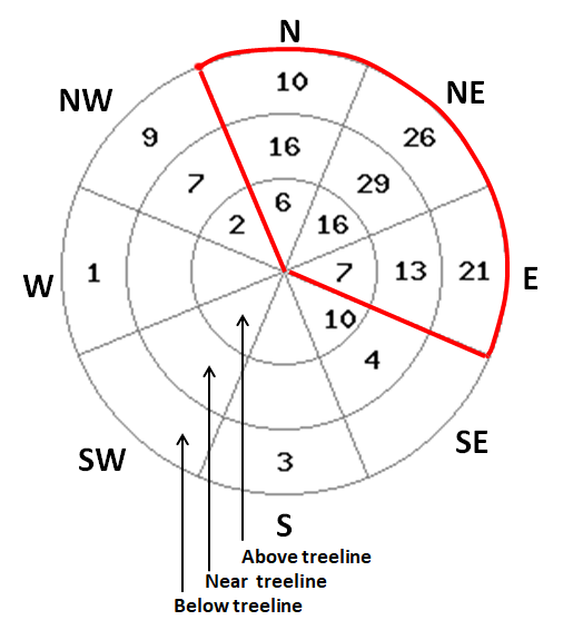
Stay on top of current conditions by reading the forecast. The danger rating, text, and avalanche problem will describe the most dangerous slopes. The avalanche rose below depicts the number of all reported slab avalanches by aspect and elevation in Colorado from Jan. 9th (the start of our last loading event) through the 17th.

You can see that most avalanche activity is occurring on north through east facing slopes, with the apparent bullseye on northeast aspects. You can easily trigger an avalanche on these aspects, on slopes steeper than 35 degrees where there is a soft slab more than a foot thick. You can greatly reduce your risk by simply avoiding these slopes.
On other slopes, traditional travel advice for dealing with persistent weak layers is appropriate. Watch for cracking and collapsing, anticipate triggering avalanches remotely and from below, and give yourself a buffer around slopes greater than 30 degrees in areas where you experience obvious signs of instability.
Given the poor snowpack structure with reactive and well developed depth hoar, we probably won’t see Low (Level 1) at all elevations any time soon. It also won’t take much for avalanche danger to rise. New snowfall of 6 inches or more with just a little wind, and we’re likely to see more natural avalanche activity. At that point we could cross the line back to Considerable danger. A larger load of a foot or more in less than 24 hours, and we could see High (Level 4) danger.
The bottom line is that MODERATE avalanche danger (especially the flavor of Moderate we’ve been dealing with lately) doesn’t mean safe. It means you can trigger serious, even lethal slides unless you pay careful attention to slope angle and aspect. Keep this in mind as you are preparing for your day in the backcountry, and make sure to read the summary and/or discussion in the avalanche forecast. It could save your life or the life of your partner.


