About 11:30 on 01/04 a snowboarder was caught and killed in a large avalanche between Vail Pass summit and East Vail. The path is known as CDC. The terrain was steep, 35-39 degrees, with an east to east-north-east aspect just at treeline. The large hard slab was 2 to 7 feet deep, 130 feet wide, and ran 800 vertical feet (HS-AR-R4D3-O/G). The slide initiated on an old bed surface, but quickly ran to ground. The avalanche carried the boarder over at least one cliff band and into a group of small trees. The other two party members quickly found the boarder, but they needed a rescue group to transport the victim out of the complicated terrain. The victim was the only party member on the slope at the time. All three party members were carrying avalanche beacons, shovels, and probes.
The Vail area had seen significant snow since Thanksgiving 2007. Along with the snow had come consistent and moderate to strong winds with very little break between storm cycles. Early season snows fell in October, but a long dry spell with moderate to even warm temperatures melted off much of the snow below treeline. Where the October snowfalls survived, snow on the ground was subjected to large temperature gradients and became a weak layer that would cause problems well into the 2007-08 season.
On January 4th A, B & C exited the Vail ski area and hiked to the top of 11,816 ft Red Mountain, at the top of the East Vail Chutes. The day’s weather was cloudy with light to moderate snow and moderate to strong winds from the west. A had skied the CDC path a couple of times already this season, and several times the season prior. He was familiar with the terrain as was C. B had been into the East Vail area in the past, but not CDC. A looked at the CAIC forecast the night before and recalled the avalanche danger below treeline was rated moderate. All three party members were carrying avalanche beacons, shovels, and probes.
CDC is an east facing avalanche path, which is a sub path within the larger East Marvins Bowl. It has a large, sparsely timbered terrain fetch just up stream (Outer Mongolia at the Vail ski area), which provides ample snow for transport into the chutes with prevailing westerly winds. The East Vail Chutes are well known for wonderful powder and are a very popular area for sidecountry riding. Many paths are loaded at the top, with either cornices or convex rolls. Starting zones often hang over cliff bands, dense forest or small trees that have survived periodic avalanche activity. Many starting zones are in the 35 to 40 degree steep range.
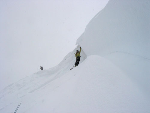
A had a helmet cam which he set-up and had switched on just prior to looking into CDC on January 4th. A talked about some of the terrain features in CDC and told both C and B to avoid the cornice a little further south of CDC. C provided a quasi belay anchor for A and A proceeded to stomp repeatedly on the convex roll at the top of CDC. After a number of jumps A triggered a small, one foot deep hard slab (HSAScR1D1O) which ran to the top of the first cliff band, an estimated 100 vertical feet. This slide was about 30-40 feet wide. After it stopped A told both C and B to stay on the bed surface to enter CDC. A then skied to the first prominent bench and pulled out rider’s right, towards East Marvins. C rode second and pulled out just up hill from A.
B was the third member to enter the chute. While standing at the 1st cliff band above A and C, B was engulfed by the powder cloud of a large avalanche and was carried to a bench about 750 vertical feet lower down the slope. B was carried over 3 cliff bands and swept through numerous small pine trees before being buried about 4 feet deep, just uphill from the toe of the debris.
Both A and B narrowly avoided being swept up in the flowing debris as it swept downhill. A quickly switched his beacon to receive and picked up C who was a little slower getting his beacon switched over. A moved up hill to search the debris deposited in the first bench while C moved down slope to search for B lower in the path. C located and began to dig B out within about 13 minutes of the accident. A arrived several minutes later and helped to dig B out. B was not exactly prone. It looked like his snowboard had acted as an anchor because it was deeper then his head. The pair began CPR and the Vail Ski Patrol was notified.
The snowpack was generally a one finger to pencil hard slab. The fatal avalanche was a hardslab avalanche triggered by B, large relative to the path and capable of breaking trees or burying a car (HS-AR-R4D3-O/G). All three crossed the slab at what would be the deepest point of the crown. The bed surface the slide intitally failed on was also hard, but below the bed surface the snow pack was generally 4 finger facets. The weak layer was 1 cm thick layer of small, 1 mm facets. The slide quickly failed to the ground. The avalanche started along a convex roll on an east-northeast aspect at 11,730 feet. The crown averaged 4 feet deep, with a maximum of 7 feet. The slope angle averaged 35 degrees in the starting zone. The slide was 130 feet wide and ran 790 vertical feet.
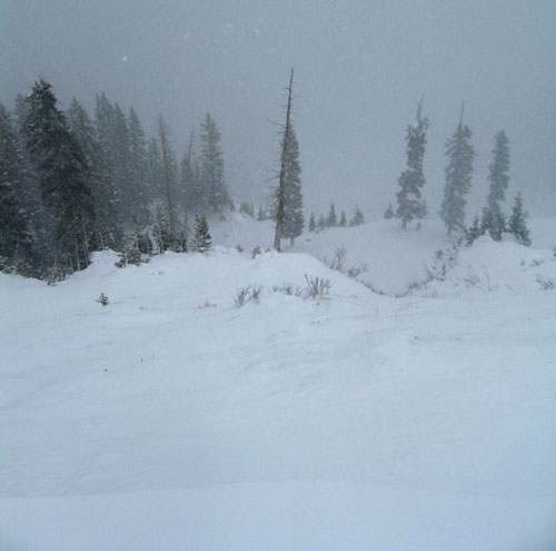
Looking down the path from just above the crown.
The deepest part of the crown.
The forecasted avalanche danger for the Vail Summit Zone was MODERATE on all aspects near treeline. The forecast warned that the snowpack was "complex and potentially tender [in] some areas" and that "most of the activity has occurred at and above treeline on north east through south east through south west aspects." Over the previous week, the forecasts mentioned several natural and human triggered avalanches in the Vail backcountry.
Previous avalanche fatalities in the Vail backcountry:
Toepfer, 20080227